

Consultation on the Concept and Masterplan
Map Key
| Thrive Site Location | |
| Railway Station | |
| Railway Line |
touch_app Scroll down to read more
This second stage of consultation has now closed, but you are still welcome to provide comments and suggestions via our online survey.
Welcome to IM Properties’ second stage of consultation on our proposals for Thrive: a strategic
and future-facing employment park. Thrive will host emerging and established economic clusters,
including advanced manufacturing, R&D and logistics. Thrive is near to Junction 9 of the M42.
The first stage public consultation presented our emerging vision for Thrive, held in late 2023.
We thank everyone who took part. We have listened to a broad range of feedback while developing
the concept for Thrive and a more detailed masterplan.
You can see the first stage public consultation on the vision here:
We are now inviting your feedback on our concept and detailed proposals.
Scroll this menu and look out for blue highlighted text like this - it will indicate interactive features on the map.
We are promoting Thrive through North Warwickshire Borough Council's (NWBC) “Employment Development
Plan Document”. This is with a view to the site's selection as an employment allocation. We are preparing
a planning application alongside this promotion.
This interactive website presents our masterplan and explains how we have taken feedback on board. We invite
you to complete a short survey where you can share your feedback. Your views matter to us.
This new survey on the second stage public consultation will close on Sunday 6th October 2024.
Once this second stage of consultation ends, we will consider your feedback and respond accordingly. We shall
then finalise the proposals and submit a planning application.
Thrive’s Strategic Locational Advantages
Map Key
| Thrive Site Location | |
| Peddimore and Langley SUE Boundaries | |
| North Warwickshire Borough | |
| East Birmingham & North Solihull Growth Zone | |
| UK Central Hub | |
| Urban/Built-up Areas |
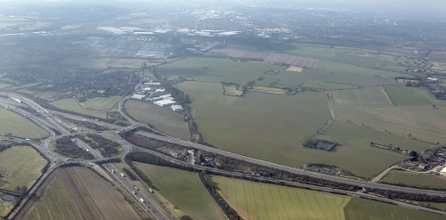
There is an urgent need to identify and deliver new strategic employment land in North Warwickshire. This is to meet the
requirements of a range of modern businesses in the region. North Warwickshire forms part of the M42 corridor; a focus
for economic growth in the Midlands. In this context, “strategic” means land over 25 hectares in size. This region lacks
available strategic employment land, with no deliverable “brownfield” sites of the required scale.
In the first stage of public consultation, we explained Thrive’s prime location. The 124-hectare site benefits
from excellent access to the strategic road network including the M42, M6 and M6 Toll. Major rail freight terminals are
located nearby at Hams Hall and Birch Coppice. Thrive has excellent access to major labour markets across the West Midlands
and Warwickshire.
This immediate need has been confirmed through various independent assessments. It has also been confirmed by a Government-appointed
Planning Inspector in a recent planning appeal decision. This decision (APP/R3705/W/24/3336295) was in relation to employment
development on land north-east of Junction 10 of the M42.
Thrive will form part of an advanced manufacturing and logistics ecosystem, which includes: MIRA near to Nuneaton,
the Greenpower Park including the UK Battery Industrialisation Centre at Coventry, and Jaguar Land Rover manufacturing facilities in Birmingham
and Solihull.
Thrive will provide space for businesses looking to capitalise on the region’s strengths. Businesses will benefit from the significant
opportunities associated with a rapidly-changing economy. The site can support North Warwickshire’s ambition for more high quality,
skilled jobs within key growth sectors. You can read more about this in the
North Warwickshire Economic Development Strategy and Action Plan (2023-2030).
Thrive will provide a pipeline of local jobs suited to the skills and expertise of the local workforce. This will sit alongside a plan
to support access for all to employment opportunities.
How your feedback shaped our proposals

Map Key
| Illustrative Site Boundary | |
| Key issues and opportunities raised during Stage 1 consultation |
Between November and December 2023, we held a first stage public consultation on our emerging vision for Thrive.
We held discussions with a wide network of organisations across health, education, community, business and employment
sectors. We also held discussions with individuals, including youth groups.
These conversations helped us to understand some of the key issues that affect the local communities today. We also
heard the concerns that arose in response to our vision.
You told us you had concerns around:
- The need for, and the principle of, development in the Green Belt;
- Thrive’s potential visual impact;
- Connectivity and traffic impacts;
- The environment, including the impact on nature;
- Local socio-economic challenges; and
- Local employment challenges, and the future workforce.
We have listened to this feedback while shaping our proposals.
Click on the map marker to find out more about the opportunities we have identified.
The following sections explain how our proposed masterplan responds to some of the specific issues raised. They explain how our approach seeks to address the project's socio-economic and environmental context.
Our Concept for Thrive
Map Key
| Thrive Start | |
| Thrive Advance | |
| Thrive Logistics | |
| Thrive Connect | |
| Thrive Community | |
| Thrive Environment | |
| Mixed: Manufacturing and/or Logistics | |
| Key Development Zones |
Thrive is an ambitious and innovative proposal to create a future-facing employment park. Manufacturing, logistics, and high-growth
businesses will all find a home here. Thrive will appeal to local entrepreneurs, growing businesses, and larger companies seeking a
prime location in the centre of the UK. The development will represent over £500m of investment.
The concept for Thrive is the creation of a number of development zones in a parkland setting. These zones will provide spaces for
a range of employment uses and building types/sizes.
The map shows our Thrive concept plan. Click on the map markers to find out more.
Thrive's supporting infrastructure will provide wide-ranging benefits to local communities.
The following section explains how this concept has led to the development of the current illustrative masterplan.
Our Illustrative Masterplan for Thrive
Map Key
| More information about our masterplan |
The map shows our current illustrative masterplan for Thrive. This design has been developed over the several months since the first stage of consultation. We have taken this feedback through a multi-stage design process. This process evolved our vision into our concept plan, and subsequently into this illustrative masterplan.
Click on the map markers to read more about our current illustrative masterplan.
This masterplan builds on our concept, shaping the development into distinct zones. Each is designed to balance
density and openness, and encourage active modes of travel. These zones are framed by the largest area, Thrive
Environment, which features extensive and diverse green and blue infrastructure.
Our masterplan contains a combination of outline and detailed planning elements. This means that we know how
some aspects of our design will look, such as the large, landscaped area. It means other aspects, such as the
buildings, are subject to certain design “parameters” and are not yet fixed.
The masterplan we present on this website shows one way the buildings could be laid out and how they might look.
This could vary, but will be subject to design parameters, such as maximum building heights.
Thrive’s Design and Landscaping
Map Key
| Illustrative photomontages of external views | |
| Illustrative artist impressions of internal views |
Our proposed masterplan for Thrive is landscape-led and has been carefully developed to reduce the visual
impact of the development, be appropriate to its surroundings and meet the needs of future business occupiers.
Our aim is to create a high-quality and interesting place to work.
A landscape and visual impact assessment has informed our approach. This means proposed development zones have
been carefully positioned within the site. Significant green “buffers” will take the form of extensive areas of
tree and hedgerow planting on boundaries, including landscaped bunds. This will help soften short and long
distance views of buildings and their service yards.
Click on the map markers to view an artist's impression of how Thrive will look from a variety of viewpoints in the local area.
Around half of the site will be green infrastructure. This will create large areas of open and amenity space for future
occupiers and local residents.
A central green corridor will connect to a mobility hub at the heart of the site. This mobility hub will provide the site’s principal
bus stop, covered waiting areas and bicycle parking/storage and repair facilities. It will also provide a location to accommodate other
potential active travel modes such as e-bike and e-scooter parking, hire and charging.
A high-quality palette of materials will be used for premium buildings. These buildings will be seen from short distance views,
filtered by new tree planting and hedgerows. Our proposed roof form and elevational treatment will aim to lessen the visual
impact of the buildings in the wider landscape.
Note on the illustrative internal views
The illustrative artist impressions of internal views, along with the illustrative photomontages depicting external views of the site,
reflect the masterplan and present the proposed landscaping in its fully developed state. While it is recognised that the landscaping will take time to
reach this established condition, key areas of the site will be planted with mature vegetation from the outset to provide strategic
screening.
Note on the illustrative external views
The external photomontages utilise Google Maps Street View images. The Google Maps Street View car typically captures images from a camera
mounted at a height of about 8.2 feet (2.5 meters) above the ground. This height allows for a wide and clear view of the surroundings,
but it does result in a perspective slightly higher than an average person's eye level, which is generally around 5 to 6 feet (1.5 to 1.8 meters).
Access and Infrastructure:
The Strategic Approach
Map Key
| Illustrative Site Boundary | |
| Proposed site access | |
| Link to Ryefield Lane | |
| Proposed highway infrastructure | |
| 23% | % impact of AADT - annual average daily traffic (please zoom in to view detail) |
| Expected total vehicle (and HGV) numbers during: | |
| 16 (2) | Peak morning hour |
| 244 (54) | 24 hours |
| and along: | |
| Motorways | |
| Primary and secondary routes |
Well-managed access and highways connections are vital for a successful employment park, to reduce impact
on the local road network.
Our transport work has assessed the potential travel demand to and from the development. It has identified
appropriate mitigation works to ensure that impacts on the local highways are not significant.
The map shows the total expected number of vehicle journeys to and from our proposed development during
peak morning hour. The numbers in brackets indicate the expected number of HGVs within this peak hour.
Drag the slider below to toggle between expected total vehicle (and HGV) numbers during peak morning hour and during a 24 hour period.
Thrive’s principal point of access for vehicles will be via a new signalised junction at Dunton Lane. This is to the east of the site, where it meets the Lichfield Road (A446). We are exploring a secondary access via Grove Lane/Ryefield Lane to the north
The blue map markers show the locations of these two access points. Click on them to find out more.
We have started to consider the possible impact of background traffic on Curdworth, Wishaw and Over Green,
following feedback from the first consultation. As a result, no vehicular access to the site is proposed to
the west via Curdworth/Wishaw Lanes. These accesses will be restricted to pedestrians, cyclists, buses, and
emergency services.
Due to its alignment through the site, the lightly used Blindpit Lane will need to be closed to vehicular
traffic. A new bridleway link will provide connection between Curdworth Lane and Church Lane. Existing public
rights of way through the site will be retained in a new alignment.
Click on the map markers to find out more about the highway infrastructure proposed in our current illustrative masterplan.
We know that the A446 is a busy route. Other junctions along this corridor could also require improvement. We
have undertaken preliminary work using Warwickshire County Council’s traffic model. This has indicated that
some junctions may require mitigation works. These include Bassetts Pole Island, Grove Lane, the Belfry Island,
and M42 J9.
Transport assessment work is yet to be completed to understand the full impact of Thrive on local highway
infrastructure. This will inform what specific mitigation may be required. This involves working with Warwickshire
County Council as local highway authority and National Highways. This work will model short, medium and long-term
traffic impacts, including allowing for traffic growth from other planned development.
Currently highway infrastructure improvements are:
- Principal access from Dunton Lane to A446 (signalisation and localised widening).
- Internal highways designed to handle the projected vehicular use with well designed and simple routing.
- A Bus Gate to Curdworth Lane; restricting access to all non-bus traffic on Curdworth Lane, Over Green.
- An on-site, off-road HGV parking facility for vehicles servicing the site;
- Further consideration of traffic calming measures and enhancements to rural roads around Over Green and Wishaw. This is subject to agreement with Highway Authorities and further formal consultation.
Sustainable Travel

Map Key
| Proposed sustainable travel initiatives | |
| Existing Public Right of Way (PROW) footpath to remain | |
| Existing PROW | |
| Proposed PROW diversion | |
| Proposed Permissive Paths | |
| Walking/cycle route to connect to Peddimore | |
| Birmingham & Fazeley Canal Towpath | |
| Peddimore On-Road Pedestrian/Cycle Routes | |
| Peddimore Permissive Paths | |
| Stopped Up Blind Pit Lane | |
| Stopped Up Dunton Lane (access maintained for non-motorised users) |
Our priority is to maximise sustainable travel at Thrive. We will achieve this by facilitating and promoting opportunities to walk, cycle and use public transport. We will also encourage car sharing.
A number of transport issues were identified through the first stage of consultation:
- Poor public transport, affecting job access and increasing the number of private journeys;
- High cost of private cars, especially for younger people;
- Concerns about access, capacity, and safety on Dunton Island (J9 M42), including the potential for Thrive to cause more traffic on the A446 and through the villages;
- A lack of safety on Kingsbury Road, which could be made worse by an increase in HGVs; and
- Poor active travel connectivity between local villages.
Click on the map markers to view these opportunities to improve travel in the area.
We have listened to your feedback and identified several opportunities to improve travel in the area and address your concerns:
- Create an on-site mobility hub to serve employees as well as the local community. This hub will comprise a public transport and active travel interchange, as described above;
- establish pedestrian and cycle routes across Kingsbury Road at the White Horse, to Coleshill Parkway, and dedicated links to Peddimore and Langley;
- provide a bus terminus with direct routes to Water Orton, Minworth, Coleshill, and Sutton Coldfield (including Peddimore and Langley) with connectivity north to Kingsbury and Tamworth; and
- Upgrade the Birmingham and Fazeley Canal e.g. improved towpaths
Toggle the checkbox below to view all nearby bus routes to Thrive.
Bus Routes
| x64 Bus Service | |
| 76 Bus Service | |
| 223 Bus Service | |
| 228 Bus Service | |
| Potential options for extended bus routes to Thrive |
Sustainability

Map Key
| Thrive's sustainability proposal |
Thrive will be a “best in class” employment park that embraces new sustainability standards.
The development will deliver Net Zero Carbon Ready buildings in line with current UKGBC methodology and will target the emerging
UK Net Zero Carbon Buildings Standards
limits for whole life carbon emissions, reducing embodied upfront carbon and allowing occupiers to benefit from Net Zero Carbon in operation.
Our strategy for delivering Net Zero Ready includes insetting emissions as a priority, with careful selection of
materials that de-carbonise using innovative and Circular Economical products.
Click on the map markers to view the ways we will meet new sustainability standards.
The development is targeting a BREEAM “Outstanding” rating on larger buildings. This will represent
the first large scale development in North Warwickshire to achieve this accreditation (minimum “Excellent”
rating). It will assess factors including embodied carbon, energy, water efficiency, and ecology.
Key elements of the sustainability strategy will be:
- Generating clean and green electricity through roof mounted solar photovoltaic technology, capable of being expanded to achieve fully “Net Zero in Operation” buildings for future occupiers.
- Adoption of SMART technologies so buildings and infrastructure operate efficiently and optimise with usage demands more accurately, meaning less waste and energy consumption.
- Utility infrastructure proposals have been agreed with statutory providers, including extensive upgrading of local Broadband and Internet through new Super Fast Fibre connectivity with Openreach providing more reliable and high-speed services benefiting surrounding communities.
- Securing Energy Performance Certificate (EPC) ratings for buildings of A+ (“very efficient”).
This will include careful selection of building materials, building functionality (e.g. smart metering)
and water management. Our strategy for delivering Net Zero Ready includes insetting emissions as a priority,
with careful selection of materials that de-carbonise using innovative and Circular Economical products
The site will be designed from the outset to be resilient to the effects of climate change. It will be
designed to consider the anticipated changes under future climate scenarios.
Environment
Map Key
| Proposed biodiversity improvement initiatives |
Landscape and ecology remain at the heart of our design approach and are integral to a successful
development. Approximately half of the site will comprise green infrastructure.
Our proposals are aligned to the
Building with Nature
benchmark, the UK's first green infrastructure standard. This provides an independent assessment
of a development's delivery of good green infrastructure.
We are targeting a Biodiversity Net Gain (BNG) of 15% with all “gain” delivered on-site. This will
ensure that nature is left in a measurably better state compared to the current position i.e. before
the development took place.
This will be achieved through:
- Wildflower meadows, wildlife boxes and pollinator gardens;
- Providing a green parcel of land in Over Green for landscaping and recreational use;
- Delivering schemes with local partners including the Warwickshire Wildlife Trust, the Butterfly Conservation Trust and Minworth Action Projects;
- Providing wetlands, woodlands, community allotments and community orchards.
Click on the map markers to view the ways we will achieve 15% Biodiversity Net Gain.
Flood risk will be mitigated through a surface water drainage strategy. This will use Sustainable
Drainage Systems (SuDS) to manage surface water run-off. This is designed to accommodate a 1 in
100-year storm event including a 40% allowance for climate change.
We have designed Thrive to retain and protect veteran trees and deliver a SuDS-led drainage approach.
Thrive will create varied and accessible amenity spaces. The vast majority of green infrastructure will
be delivered as part of the “day one” site infrastructure works. This means trees and vegetation will
be planted at the earliest stages to ensure early growth and establishment.
Community and Social Value

Map Key
| Our Social Value Strategy |
At Thrive's heart is the aim of creating a successful business community, which supports existing
neighbouring communities. This is much more than a real estate project.
Our work and consultation feedback has identified several disparities within the wider community.
We find these in economic opportunity, education, career aspirations, health and socio-economic
conditions. It has also identified the challenges in sustaining community facilities.
Thrive’s Social Value Strategy will be underpinned by four key themes:
- Encouraging a new generation of workers
- Diversifying the employment base
- Improving health and wellbeing
- Increasing accessibility
These themes have influenced our approach to master-planning. They have informed the activities
and initiatives that will accompany Thrive's delivery and occupation.
The future workforce
We are in ongoing conversation with a range of partners to discuss ways to encourage and diversify
the future workforce. Initiatives could include:
- The creation of a fund to support a new generation of workers, complementing the objectives of the Local Skills Investment Plan.
- Offer STEM learning packages to local schools, to educate and inspire our young people. STEM stands for Science, Technology, Engineering, and Mathematics in an educational context.
- Enhance careers advice in local schools, including the identification of an ambassador for Thrive.
- A programme that targets ‘harder to reach’ wider communities with new pathways to employment.
- Provide flexible shared spaces, including the provision of shared classroom spaces, to support both employees and the community.
Improving health and wellbeing
Thrive will provide spaces to encourage social interaction, physical activity and sustain mental
health. These spaces could potentially host services such as new businesses and local residents
and communities. These could deliver services such as occupational health, or help fill gaps
identified in the local area, such as health services.
We would like to discuss the appetite for community ownership and management of some of these spaces with you.
Specific benefits include:
- Enhancements to Church Pit angling lake, including designated parking
- A high quality central area of hardstanding for community events
- Space for formal and informal recreation/sports
- Community allotments and orchards
- Extensive greenspace including parkland which will be accessible to local communities. The greenspace will include an outer perimeter path, or “trim trail”, measuring nearly 5km which will provide a recreational resource for walkers, joggers, cyclists and (in part) horse riders. The trim trail will connect to paths permeating throughout Thrive, and wider public rights of way (including the Curdworth “Circular Walk”).
Improving accessibility
The mobility hub will increase accessibility to the site whilst promoting active travel, such as walking and cycling.
It will provide a welcoming environment for those using buses to/from and through the site.
Community Fund
Alongside but separate to the planning application process, is our commitment to establish a Thrive Community Fund.
This will be delivered by an established community foundation. It will provide grants to support community projects
and grassroots organisations. This is in line with IM Properties’ sustainable vision and framework presented in
“Sustainable Futures” (2022).
Together, these features will ensure that Thrive creates a legacy for North Warwickshire. We will create a place
which sets new standards. Thrive will offer significant community benefits for the wellbeing of those who work there
and the surrounding communities.
Share your thoughts

Map Key
| Illustrative Site Boundary | |
| Click to answer the survey | |
| Railway Station | |
| Railway Line |
This second stage of consultation has now closed.
Thank you for taking the time to read about our concept and masterplan for Thrive.
We would now love to hear from you. Your feedback is very important to us.
Click on the button below to answer the survey.
question_answer Answer the survey here
Next steps & in-person events:
This second stage of consultation will end on Sunday 6th October 2024.
We will use this feedback to help us prepare our planning application for submission.
IM Properties are holding public drop-in events this September. At these, you can speak
to our team about our detailed masterplan and share your feedback in-person.
These events are free for anyone to attend and will be held on:
- Friday 20 September 4PM - 8PM at Curdworth Village Hall (70 Coleshill Road, Curdworth B76 9HH)
- Saturday 21 September 10AM - 2PM at St. Nicholas Church Hall (Glebe Fields, Curdworth B76 9ES)
- Wednesday 25 September 4PM - 8PM at Middleton Village Hall (Church Lane, Middleton, Tamworth B78 2AW)
Further contact:
In addition to answering the survey above, and attending our in-person events, you can get
in touch by:
Telephone: 03308 384 199
Email: info@thrivepark.co.uk
Write to us: IM Properties, c/o Camargue, 11 Waterloo Street, Birmingham, B2 5TB
Brought to you by:
An
Engaged Space community engagement on behalf of IM Properties. Powered by Deetu.Got a story to tell? Get in touch.

touch_app Back to the start
